


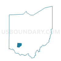
PRECINCT WAYNE, Clinton County, Ohio
About
Outline

Summary
| Unique Area Identifier | 643671 |
| Name | PRECINCT WAYNE |
| County | Clinton County |
| State | Ohio |
| Area (square miles) | 31.58 |
| Land Area (square miles) | 31.55 |
| Water Area (square miles) | 0.03 |
| % of Land Area | 99.91 |
| % of Water Area | 0.09 |
| Latitude of the Internal Point | 39.41689650 |
| Longtitude of the Internal Point | -83.63190690 |
Maps


Graphs
Select a template below for downloading or customizing gragh for PRECINCT WAYNE, Clinton County, Ohio


Neighbors
Neighoring Voting District (by Name) Neighboring Voting District on the Map
- CONCORD Voting District, Fayette County, OH
- Voting District FAIRFIELD E, Highland County, OH
- Voting District FAIRFIELD W, Highland County, OH
- GREEN Voting District, Fayette County, OH
- PRECINCT GREEN, Clinton County, OH
- PRECINCT RICHLAND, Clinton County, OH
- PRECINCT UNION SOUTH, Clinton County, OH
Top 10 Neighboring County Subdivision (by Population) Neighboring County Subdivision on the Map
- Fairfield township, Highland County, OH (3,764)
- Richland township, Clinton County, OH (3,573)
- Union township, Clinton County, OH (3,085)
- Green township, Clinton County, OH (2,473)
- Concord township, Fayette County, OH (901)
- Wayne township, Clinton County, OH (716)
- Green township, Fayette County, OH (532)
Top 10 Neighboring Unified School District (by Population) Neighboring Unified School District on the Map
- Wilmington City School District, OH (20,781)
- Miami Trace Local School District, OH (15,618)
- East Clinton Local School District, OH (7,919)
- Fairfield Local School District, OH (4,946)
Top 10 Neighboring State Legislative District Lower Chamber (by Population) Neighboring State Legislative District Lower Chamber on the Map
Top 10 Neighboring State Legislative District Upper Chamber (by Population) Neighboring State Legislative District Upper Chamber on the Map
Top 10 Neighboring 111th Congressional District (by Population) Neighboring 111th Congressional District on the Map
Top 10 Neighboring Census Tract (by Population) Neighboring Census Tract on the Map
- Census Tract 9546, Highland County, OH (5,645)
- Census Tract 9264, Fayette County, OH (4,324)
- Census Tract 9651, Clinton County, OH (4,314)
- Census Tract 9643, Clinton County, OH (3,712)